Historic Maps of Florida and Union County
Union County emerged into being in 1921 as Bradford County was divided. Over the years Florida was developed by the Spanish, British, and the United States. During this time, the area that now comprises Union County was a part of many other counties.
Union County was initially included in St. Johns County when Florida was acquired from Spain in 1821. It then was incorporated into Alachua County (1824), Columbia County (1832), New River County (1858, later renamed Bradford in 1861) and almost exactly 100 years later, become Union County on October 1, 1921. To view the progression of Florida’s counties, and what we now call Union County, select the various maps in the map gallery below. The maps are shown in chronological order.


Map References (in order shown above)
1. Union County was initially part of Duval County as shown in this 1823 Map.
Vignoles, Charles Blacker, and Henry Schenck Tanner. Map of Florida. [S.l, 1823] Map. Retrieved from the Library of Congress, https://www.loc.gov/item/2003627045/. (Accessed July 15, 2017.)
2. In1823 Map, Florida consisted of only four counties (Escambia, Jackson, Duval & St. Johns).
Lucas, Jr., Fielding, Map of Florida. Baltimore, 1823. Birmingham Public Library, Cartography Collection, Florida Maps. http://bplonline.cdmhost.com/digital/collection/p4017coll7/id/127/rec/20 (Accessed July 15, 2017)
3. This 1833 map reflects the creation of Alachua County.
Finley, Anthony, Florida. Philadelphia,1833. Birmingham Public Library, Cartography Collection, Florida Maps. http://bplonline.cdmhost.com/digital/collection/p4017coll7/id/128/rec/1(Accessed July 15, 2017)
4. This 1839 Army created map during the Seminole Wars shows the placement of forts.
Mackay, John and J.E. Blake, Map of the seat of war in Florida. Washington, D.C., Head Quarters, Army of the South, 1839. University of South Florida, Digital Collections Home, Florida Map Collection (Accessed July 15, 2017).
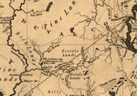
5. Columbia County is now shown on this 1846 map as is “EllisVille”.
Bruff, Joseph Goldsborough, United States Army. Corps Of Engineers, and United States Congress. Senate. The State of Florida. [S.l, 1846] Map. Retrieved from the Library of Congress, https://www.loc.gov/item/2002624052/. (Accessed July 15, 2017.)
6. North Central Florida is shown on this 1856 map. Columbia eventually will be 5 counties.
Drew, Columbus. Map of the State of Florida showing the progress of the surveys; from the annual report of the Surveyor General for 1856. Jacksonville, 1856. Map. Retrieved from the Library of Congress, https://www.loc.gov/item/98688455/. (Accessed July 15, 2017.)
7. This 1862 map shows the emergence of New River County (now Baker, Bradford & Union).
Colton, J. H, and Lang & Laing Lith. Colton's map of the southern states: including Maryland, Delaware, Virginia, Kentucky, Tennessee, Missouri, North Carolina, South Carolina, Georgia, Alabama, Mississippi, Arkansas, Louisiana, Texas: showing also part of adjoining states & territories locating the forts & military stations of the U. States & showing all the rail roads, r.r. stations & other internal improvements. New York: Published by J.H. Colton, 1862. Map. Retrieved from the Library of Congress, https://www.loc.gov/item/2009579250/. (Accessed July 15, 2017.)
8. By1888, New River County had been split into Baker and Bradford counties.
Elliott, D. H. A new sectional map of Florida issued by the land department of the South Florida R. R. Co. and the Plant Investment Co. Sanford, Fla, 1888. Map. Retrieved from the Library of Congress, https://www.loc.gov/item/98688458/. (Accessed July 15, 2017.)
9. Finally, this 1921 map reflects the creation of Union County with Lake Butler the County Seat.
Poates, L.L., Florida. 1921. Exploring Florida: A Social Studies Resource for Students and Teachers Exploring Florida: A Social Studies Resource for Students and Teachers . Florida Center for Instructional Technology, College of Education, University of South Florida. <http://fcit.usf.edu/florida/maps/1900/poat21z.htm>. (Accessed July 15, 2017]

Copyright 2024. Thomas M. Riherd, II. All rights reserved.